*
Interactive Map
*
Global Orthographic Map
*
Eclipse Path Through Asia
*
Eclipse Path Through India
*
Annular Solar Eclipse of 2010 January 15
| Solar eclipse of January 15, 2010 |

Map
|
| Type of eclipse |
| Nature |
Annular |
| Gamma |
0.4002 |
| Magnitude |
0.919 |
| Maximum eclipse |
| Duration |
11m 8s |
| Coordinates |
1.6N 69.3E |
| Max. width of band |
333 km |
| Times (UTC) |
| (P1) Partial begin |
4:05:28 |
| (U1) Total begin |
5:13:55 |
| Greatest eclipse |
7:07:39 |
| (U4) Total end |
8:59:04 |
| (P4) Partial end |
10:07:35 |
| References |
| Saros |
141 (23 of 70) |
| Catalog # (SE5000) |
9529 |
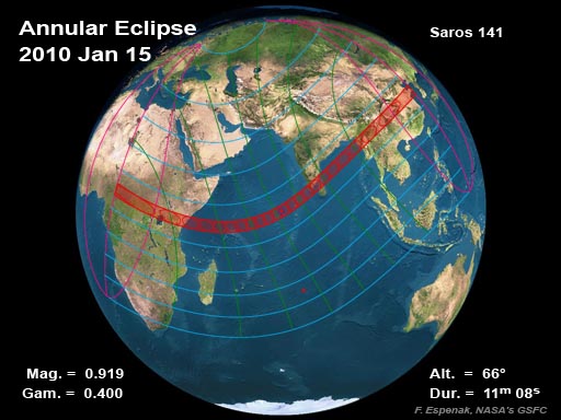
On Friday, 2010 January 15, an annular eclipse of the Sun is visible from within a 300-km-wide track that traverses half of Earth. The path of the Moon's antumbral shadow begins in Africa and passes through Chad, Central African Republic, Democratic Republic of the Congo, Uganda, Kenya, and Somalia. After leaving Africa, the path crosses the Indian Ocean where the maximum duration of annularity reaches 11 min 08 s. The central path then continues into Asia through Bangladesh, India, Burma (Myanmar), and China. A partial eclipse is seen within the much broader path of the Moon's penumbral shadow, which includes eastern Europe, most of Africa, Asia, and Indonesia.

Click to enlarge.
Google Maps and Solar Eclipse Paths
Orthographic (Global) Map of 2009 Total Solar Eclipse
Map of 2009 Eclipse Path Through Asia
Map of 2009 Eclipse Path Through India
Acknowledgments:
- "Eclipse Predictions by Fred Espenak and Chris O'Byrne (NASA's GSFC)"
- For more details please see, Total Solar Eclipse of 2009 July 22 @ NASA
|


